On-Map Measurement

Trace the lawn on the map.
Quote the exact square metres.

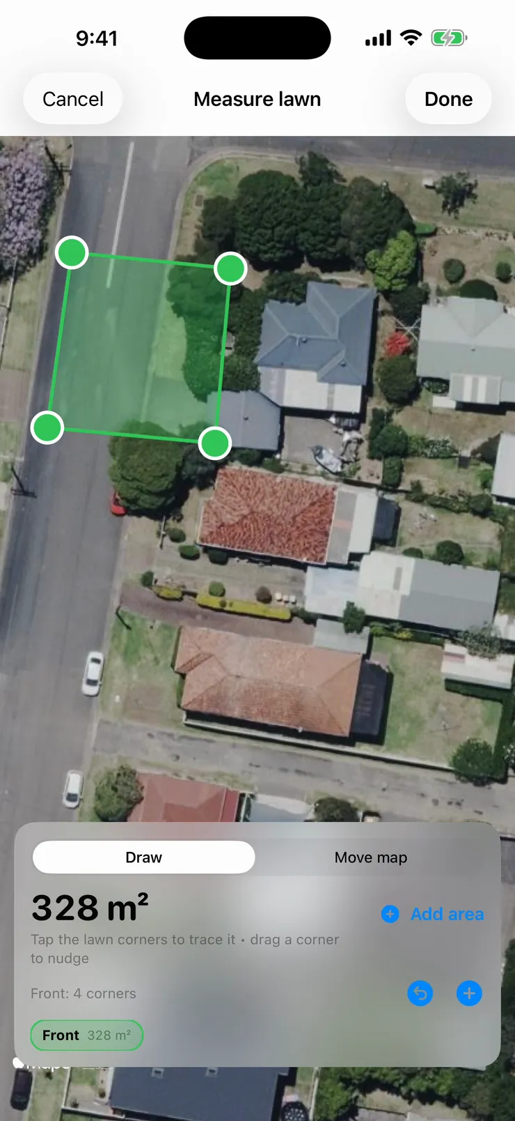
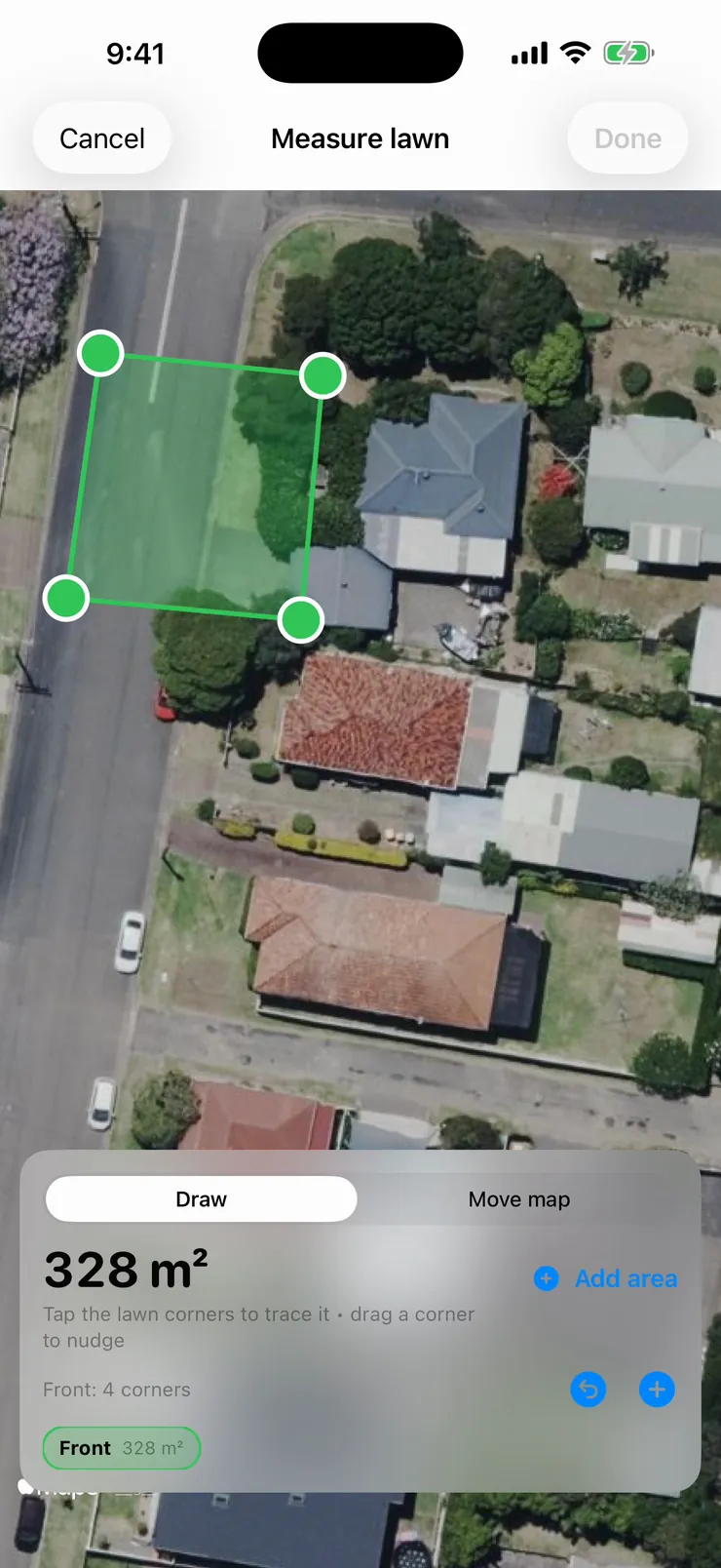
Tap the corners of the lawn on satellite view and FieldForge calculates the area as you go — then prices the quote off that confirmed measurement instead of a guess. Works from the couch or standing on the verge, from a courtyard to rural acreage.

Four taps. One real number. No more guessing.
1
Pull up the property
Type the address and the satellite view opens on the property — no site visit needed. Pan and zoom until the lawn fills the screen, then switch to Draw.
2
Tap the corners
Tap around the boundary and the square metres update live with every corner. Missed by a metre? Drag the corner to nudge it. Front yard done? Add the back and the verge as separate areas.
3
Price off the real number
Hit Done and the confirmed measurement flows straight into the quote — the AI prices area-based work off it and judges condition, access and complexity around it. No more "she'd be about 300 square, mate."
Four taps.
328 square metres.

The map stays locked while you're drawing, so you're placing corners — not fighting the pan. Every tap updates the running total live, an undo button walks back the last corner, and any corner can be dragged to nudge it onto the boundary. Flip to Move-map mode any time to reposition, then keep tracing. It's the difference between "roughly 300" and 328.

  • Live square-metre total updates with every corner
  • Drag any corner to nudge it · undo the last tap
  • Draw and move-map modes — trace without fighting the pan
  • Add separate areas: front, back, verge — totalled together
The measurement
follows the job.

Confirm the trace and it lands in the quote flow as a measured area — the AI treats it as ground truth and prices off it, instead of estimating area from a photo. And it's not maths-class geometry: FieldForge uses proper geodesic calculations on the real curved earth, the same approach surveying software takes. In our tests against regulation sporting fields, results came in within half a percent. Better still, the measurement saves to the property — next quote for that address, it's already there.

  • Confirmed area becomes the AI's pricing input — not a guess
  • Geodesic maths — within half a percent in our tests on regulation fields
  • Saves to the property: measure once, reuse on every future quote
  • Tap to adjust any time the yard changes
Quote flow showing the confirmed measurement — Measured: 328 square metres, tap to adjust
From courtyards
to the back paddock.

Big blocks are a different job and FieldForge prices them like one. Acreage work is measured in hectares and quoted with rates built for broad-area mowing and slashing: your real pace on the machine, a terrain loading that scales from flat and open through to heavy going, plus travel, setup and risk. The days of standing at the gate squinting at three acres and picking a number are over.

  • Hectare-based pricing built for slashing & broad-area mowing
  • Terrain loading from flat & open through to heavy going
  • Travel, setup and risk built into the rate — not forgotten
  • Engages automatically when the measured area is acreage-sized
Satellite measurement overlay with a traced lawn polygon showing 328 square metres
Little things that make it dependable.

Real-earth maths

Areas are computed geodesically on the curved earth — not flat pixel counting — so big blocks don't drift as they grow.

Remembers the property

Confirmed measurements save to the property and pre-fill the next quote for that address. Measure once.

Multiple areas per job

Front, back, verge, the odd strip behind the shed — each traced separately, totalled automatically.

Undo & nudge

Walk back the last corner with one tap, or drag any corner to sit exactly on the boundary. No starting over.

Works anywhere

Type an address and measure from the office, or stand on the verge and trace what's in front of you. Same tool.

Priced off your rates

The measured area runs through your per-square-metre rates — and the pace the app has learned from your own jobs.

On-map measurement questions
FieldForge uses proper geodesic maths — the same spherical calculations surveyors' software uses — not flat-screen pixel counting. In our tests against regulation sporting fields with known areas, results came in within half a percent. In practice accuracy is limited by how clearly you can see the boundary in the imagery: crisp suburban lawns trace very tightly, fuzzy rural tree lines take a little more judgment. Every corner can be nudged after you place it.
No. When the job is linked to a property, the confirmed measurement saves to that property and is reused automatically on the next quote. Measure once, quote off it forever — and tap to adjust it any time the yard changes.
Yes. Add as many separate areas as the job needs — front, back, verge — and FieldForge totals them. Each area keeps its own corner points so you can adjust one without touching the others.
Yes — this is where it really earns its keep. Large blocks are measured in hectares and priced with rates built for broad-area and slashing work: your pace on the machine, a terrain loading from flat through to heavy going, plus travel, setup and risk. No more eyeballing three acres from the gate.
No. Type the address and the satellite view comes up wherever you are — measure from the couch, price it, and send the quote the same day. On site works exactly the same way if you'd rather confirm boundaries in person.
Ready?

Stop guessing. Start measuring.

14-day free trial with everything included. Trace your first lawn on the map and watch the quote price itself off the real number.

Start Free Trial

No credit card. No demo call. Two minutes and you're in.